
Deep cut
Tuesday, November 3, 2026
The cupola that rounded off Delaware - the New Castle Court House and the Twelve-Mile Circle
Pull up a map and look at the top of Delaware. The line with Maryland runs ruler straight.
Pull up a map and look at the top of Delaware. The line with Maryland runs ruler straight. The top edge, where we meet Pennsylvania, bends in a smooth curve, like somebody set a dinner plate on the map and traced around it.
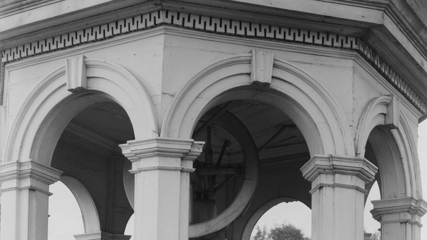
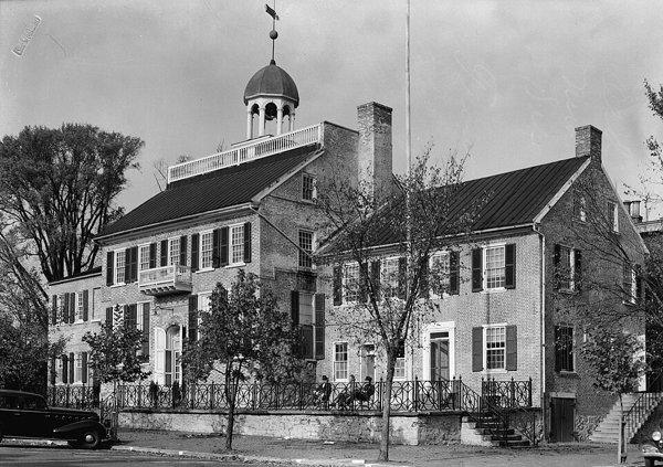
That's pretty much what happened, and the dinner plate is still standing. It's the cupola on top of the New Castle Court House on Delaware Street, and you can walk inside the building for free this week.

A circle drawn from New Castle
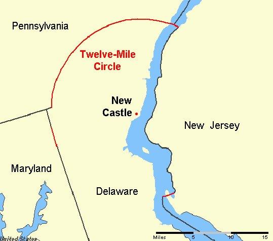
The short version starts in 1664, when the English took the Dutch town of New Amstel and renamed it New Castle. In 1681, William Penn got his charter for Pennsylvania. The Duke of York, who held the land along the Delaware River, wanted the area around New Castle kept separate, so the line was set as a circle with a 12-mile radius around the town. Penn himself landed at New Castle in 1682.
The National Park Service says the circle's first center point was the end of the Broad Dike, near Third and Chestnut streets in New Castle, and there's a marker at that spot today.
The line was first surveyed in 1701. A few years later, in 1704, the three lower counties got their own assembly, which met in New Castle. The center block of the court house you see now went up in 1732, built over an older court house from the 1680s.
How the cupola became the center
By the middle of the 1700s the center point had moved to the court house cupola. Two National Park Service pages and the building's National Register nomination all tie the arc to that cupola, and the Park Service's border marker page puts the official designation in 1750. The nomination puts it plainly: the cupola "served as the beginning point of the 12-mile radius that determines Delaware's curved northern boundary."
When Charles Mason and Jeremiah Dixon showed up in 1763 to settle the long fight between the Penns and the Calverts, the Park Service says they used the court house as the center too. Their work is why everybody knows the name of the Mason-Dixon line, even if most people couldn't tell you where it runs.

The stones and the Wedge
You can still find the line on the ground. In 1892, Captain W. C. Hodgkins resurveyed the arc and set stone markers along it. The Park Service says the mile markers carry a P on one side and a D on the other, with smaller "1/2" stones in between. The Park Service features one of those half-mile stones on its First State National Historical Park pages.
The curve didn't line up neatly with the straight lines around it, though. Where the arc, Maryland's line and Pennsylvania's line came together west of Newark, they left a small sliver of land called the Wedge that both Delaware and Pennsylvania claimed. For a long time nobody could say for sure which state it was in. It wasn't officially settled until 1921, when it went to Delaware.
Delaware owns the river
Here's my favorite part. The circle doesn't stop at the water. Inside those 12 miles, Delaware's line runs across the Delaware River to the low tide mark on the New Jersey side. If you're on the river off Wilmington or New Castle, you're in Delaware almost all the way to the Jersey shore.
That turned into a real fight in the 2000s. BP wanted to build a natural gas terminal called Crown Landing on the New Jersey bank, with a pier running out into the river, and Delaware said no. The Park Service says Delaware lawmakers even floated a half-joking bill to send the National Guard. New Jersey took it to the Supreme Court and lost. In New Jersey v. Delaware, decided in 2008, the court said Delaware could block the pier, because the part reaching into the river was in Delaware's territory. Reuters' headline that day was "Delaware can block BP LNG terminal."
So a line drawn from a cupola in the 1700s ended up deciding where a gas pier could go a few centuries later.
The building is worth the trip on its own
Most visitors come for the building's own history. On June 15, 1776, the colonial assembly voted in this building to separate from Great Britain and from Pennsylvania, which is why Delaware has Separation Day. The state's first constitution was written here that year too, and the capital stayed in New Castle until it moved to Dover in 1777. In 1848, the abolitionists Thomas Garrett and John Hunn were tried here for helping a family escape slavery, and the building is now part of the National Park Service's Underground Railroad Network to Freedom.
It's a National Historic Landmark, and it's a partner site of First State National Historical Park, so bring your park passport if you collect stamps.
How to go
- Where: New Castle Court House Museum, 211 Delaware St, New Castle. Street parking.
- When: Wednesday through Saturday, 10am to 4pm, with guided tours at 10, 11, 1, 2 and 3. Sunday, 1:30 to 4:30pm, with tours at 1:30, 2:30 and 3:30. Closed Monday and Tuesday.
- Cost: Free. Donations are appreciated.
- Tours: About 45 minutes, so get there on time. Groups over 10 need a reservation; call (302) 323-4453.
When you leave, stand on the green and look up at the cupola. Every bit of that round border on the map starts there.